2.6 Plymouth Directory maps
2.6.1 George Philip &
Son
As noted above,
the 1st Edition of the Plymouth directory included a map from Philips´
Handy Atlas maps series (Fig. 24.).
The size and the format of the directory meant that the county map chosen
fitted perfectly with one centre fold (the same format as the Handy Atlas
itself). It had the EYRE BROTHERS` SERIES OF GUIDE MAPS as title above the top
border and the address of the publishers on the map is given as 10 Paternoster
Square, London.[i]
The imprint on the title page is 26 & 27 (late 10) Paternoster Square.
The same series
of maps was used for all Eyre´s output until the 2nd Edition of the
Plymouth directory circa 1882 (see next entry) including the guide to Sussex
(Fig. 12a.) and the guide to Devon & Cornwall. It
was also this series which G P Butcher chose to illustrate his numerous
directories (see 3.1).
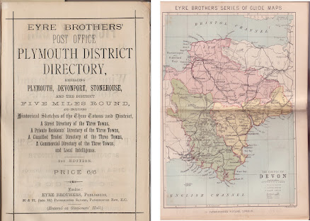
Fig. 24. Map of Devon by George Philips in Eyre Brothers´ .... Directory 1st
Edition.
2.6.2 W H Maddock
William Henry
Maddock was a printer,
engraver and lithographer in Plymouth and was active from circa 1848 to the late-1890s
with addresses at 32 Frankfort St., and in 1890 at 86 Treville Street. His only
known venture into publishing before 1880 would seem to be a map of Plymouth, A New Map of Plymouth ..., dated 1848. However,
he was a specialist lithographer and did print maps for others: he printed a
map of Exeter for Llewellyn Jewitt (1850), two maps for John Heydon (1859 and
1860), a map of Dawlish for W M Cornelius´ guide (1868) and a map of Salcombe
and Kingsbridge for James Fairweather (1884).[ii] In 1881 Maddock lithographed
and published a new map of Plymouth and the following year it was included in Eyre Brothers’ Post Office Plymouth and
Devonport District Directory (Fig.
25.).

Fig. 25. Map of Plymouth by Maddock in Eyre Brothers´ .... Directory 2nd
Edition.
This map was
originally somewhat smaller and was increased specially for the directory. It
only appeared once in the directory (1882-83) but in 1885 it was sold as a
folding map in orange covers, now published by Wood & Tozer and
lithographed by WP Cooper of Plymouth. It finally appeared in an attractive
volume of Plymouth and Devonport Views
circa 1890.
The map´s
biggest competitor was one published by William Wood in 1851 and updated
several times until 1890 at approximately ¾ the size of Maddock´s map. Although
largely an updated version of his earlier 1848 map, Maddock´s was still better
quality than Wood was selling and it is not surprising that Wood issued the
Maddock map himself in 1887 and 1890.
Maddock´s map
is an improvement on Wood. It is not only crisper and tidier in appearance but
areas which were not built up at the time of Wood´s original map (or Maddock´s
original of 1848) are included such as Ford and Mutley and the eastern regions
north of Cattewater. Surprisingly perhaps, the execution is not as good as that
of his earlier version. In 1890 both W H Foster and George Sellick would sell
an updated copy of William Maddock´s map; the former issuing it in covers and
the latter in an album of Plymouth views. A H Swiss updated it for inclusion in
1905-06 (see below).
2.6.3 Brendon & Son
Richard Nicholls Worth was a
professional writer born in 1837 at Devonport and became chief reporter for the
Western Morning News. His books History
of Devonport and History
of Plymouth were published in 1870 and 1871 respectively.
Maybe it was the success of these books, and the latter in particular, but
Worth resigned his post at the newspaper in 1876 and joined the local printing
and publishing business of Brendon & Son.

Fig. 26. Map of Plymouth by Brendon & Son in Eyre Brothers´ .... Directory 3rd
Edition.
A map of
Plymouth was included in his Guide to the
Three Towns and Neighbourhood which was published soon after. He was a
regular contributor to the Transactions
of the Devonshire Association, and also became its President. The name of
Brendon is very much
associated with Plymouth and the Transactions
which were mostly printed by that company. Worth was also active in, and became
President of, the Plymouth Institution. He died in July 1896 at Shaugh Prior.
In 1885 the Eyre Brothers chose this map to be included in Eyre Brothers’ Post Office Plymouth and Devonport District Directory
3rd Edition (Fig. 26.).
The map is an
improvement on that executed by Maddock. Although essentially the same
buildings and streets are shown there are major differences. Most striking is
the quality of the drawing: Maddock´s plan looks clumsy in comparison and the
lines and the writing of the Brendon map are crisp and clean. Changes are
noticed in that Brendon names less naval areas but these are better drawn.
Ferry Road in the west has given way to the Gunwharf, the battery on Mount Wise
appears to have been removed, Firestone Bay is named, rail lines surrounding
Mill Bay have been reduced to one approach line, Sutton Harbour becomes Sutton
Pool, the Freedom Fields have given way to Lipson Hill, the prison and the
workhouse and all of the wards are now named.
W H Hood took over the directory in 1888 and for the 4th Edition he turned again to William Brendon & Son to print a new map for the directory. Whereas the first map was a plan of the three towns, the second was more a chart of the Cattewater and Sutton Harbours (Fig. 27).

Fig. 27. Plan of Cattewater & Sutton Harbours in Eyre´s .... Directory 4th Edition.
This map is interesting from a
number of different aspects. It is a very detailed plan of the harbours and the
buildings situated there and various chemical works, a petroleum store, a
distillery and a cement works are clearly shown in Cattewater; while in Sutton
Harbour such premises as the manure works, rope walk, shipbreaking and
shipbuilding works as well as the gas works with coal store etc are all named,
some with their proprietors.
The soundings throughout the bays
are clearly taken from an Admiralty survey and the key notes that Soundings
in Fathoms & Feet below L.W.O.S.T. (Low Water of Spring Tide) and that For
Depth at H.W.O.S.T. (High Water) add 15 feet 6 ins to Soundings. The
map was drawn up by J G Inglis whose signature is found bottom left.
There was obviously discussion at the time about further developments in
and around Cattewater Quarries - where several bones of rhinoceros had been
found in a perfect state during work on the Plymouth Breakwater.[iii]
At about the time this plan was included by the Eyre Brothers, human bones some
140,000 years old had been found in Cattedown Caves.[iv]
Between the quarries and the (L&SW) railway line is a note “Site of
proposed Warehouses” and another on the river side “PROPOSED DEEP WATER QUAYS”.
None of these appear in any of the later maps.
2.6.4 John Smith
Besides the map produced for the
Eyre directory nothing more by John Smith is known. However, the map was issued
in the 6th to 11th editions with at least three updates.
The 1st edition of the directory lists a Smith, J at 102 Old Town in
Plymouth under Printers. However, the 5th and 6th editions
have extensive advertisements for John Smith at The Printing and Stationery Works (Fig. 29.). According to the text the company was
established in 1794 and had a warehouse at the Old Town address but the works
were in Notte Street. According to this advertisement, in 1893 he was publishing
the “Handy” Railway Time Table
(monthly), the Plymouth Almanac,
books on Plymouth Guildhall and the Eddystone Lighthouse as well as two maps of
Plymouth: the “Handy” map of the Plymouth
District and a New and Correct Street
Map (in 3 colours price 6d). It is possibly this latter map that Smith sold
to Hood: no copies of other work either printed or published by Smith have been
found.

Fig. 28. Map of Plymouth by John Smith in Eyre Brothers´ .... Directory from 10th
Edition.
This was by far
the most successful directory map. It appeared for the first time in 1890 in
the Fifth Edition published by W Hood. It was included, unaltered, in the Sixth
Edition issued by J Hammond. He continued to use the map for all issues until
1899 although it underwent changes in size and was updated in 1896 and 1897 to
include new developments.[v] From 1896 (8th
Edition) an extra title at top was added: Eyre´s Directory Map (Fig. 28.:
10th Edition 1898). This faith is not reflected in the quality of
the map itself. The general execution is poor even though some developments are
shown. The execution is quite crude and nowhere as good as that of Brendon
& Son. However, areas of new development such as Mutley Plain appear and
many new roads are named but the overall quality of the script rough.

Fig. 29. Advert for J Smith´s works in Eyre Brothers´ .... Directory 5th
Edition.
2.6.5 Theophilus Creber
Theophilus Creber published five
editions of the directory and two have so far been found with a map. The first contained a reissue of the final John Smith map (see above) but the 13th
edition has a new map. This seems to have been specially made and bears Creber´s
name across the top but is not found in later editions (Fig. 30.). The
author of the map is not known but Creber was responsible for the lithographic
printing as one might expect. Two copies of each of the next three issues are known
(all lacking a map, but none called for in title).

Fig. 30. Map of Plymouth for Creber in Eyre Brothers´ .... Directory 13th
Edition.
Theophilus Creber´s Copyright Plan of Plymouth,
Devonport, Stonehouse and Neighbourhood was included in 1901. Two libraries have the 13th
Edition directory with the map, two further institutes have a copy of the map
stored separately to their directories, hence dating is difficult. Creber
issued directories until 1904 (16th Edition) before it was sold.
This map
shows more recent developments than those in the previous Smith version as well
as including St Budeaux and Saltash in two inset plans. Plymouth is expanding
and built-up areas in Laira Ward now reach the Infectious Diseases Hospital,
which also seems to have been developed. The main cemetery in Mutley Ward is
now almost surrounded, but the most striking changes are the streets and
buildings at Ford (top left), and the Naval Dockyard at Keyham is shown in some
detail. For sports fans, we have the inclusion of Home Park recreation grounds
and Chelson Meadow race course. Although used by rugby clubs prior to 1900 Home
Park opened for an athletics meeting in 1901 and became the home of Plymouth
Argyle football club soon after. Just below Chelson Meadow the new railway
lines to Turnchapel and Plymstock are shown, completed 1897 they are
inexplicably omitted by Smith.
%20-%20tail.jpg)
[i] Batten & Bennett; 2000; ibid. See entry B&B 149. The
original Handy Atlas maps all have the Philip & Son publisher´s imprint
below the map and are numbered (Devon is 9). Not all the maps used by Eyre have
their imprint with their current address at the bottom. For differences to
identify loose maps (of Devon) refer to B&B 149 states 5 to 10. Eyre
Brothers´ Series of Guide Maps appears at the top of the Sussex guide map
and on all Watering Places … South England maps; Philips´ imprint is
present on North England maps top and bottom; no top imprint is present
on Wales Register maps but they have the Philips´ imprint.
[ii] Batten; 2011; Tourist Maps of
Devon; Little Silver Press; Exeter.
[iii] George Banks; 1819; A Sketch of the Breakwater and
Plymouth Sound; J Johns; Plymouth-Dock; p.11.
[iv] See also
https://royalsocietypublishing.org/doi/pdf/10.1098/rstl.1823.0011 for a
contemporary account with plans and images of the fossils.
[v] Batten; 2011; p.312.


No comments:
Post a Comment